


It's easy to say Abu Rayhan Muhammad ibn Ahmad al-Biruni
What if the Earth is a cylinder?

These days I have been having fun writing an application for the Fondo Italiano per la Scienza (Italian Science Fund), a national grant that resembles the European ERC. It is a kind of fun with latent masochistic overtones though, particularly when you are basically forced to write your budget twice: once in the milestones form (which are actually more like work packages, but so be it) where you have to provide a time outline of your projected expenses, and once in the budget section, where you have to justify each item of expenditure. The two values must match, or the submission cannot proceed.
But this is all over now: I finally submitted the application a few hours ahead of the deadline, so I can relax and concentrate on what really matters. What about trying to measure the radius of the Earth?
You may recall an old post where I suggested that we try to follow in the steps of al Biruni (973-1050), the Persian scholar who, quoting Wikipedia
devised a novel method of determining the Earth's radius by means of the observation of the height of a mountain. He carried it out at Nandana in Pind Dadan Khan (present-day Pakistan). He used trigonometry to calculate the radius of the Earth using measurements of the height of a hill and measurement of the dip in the horizon from the top of that hill.
Sounds easy, right? The Euganean hills are a few miles West of my place and, as long as we trust the elevation data reported online, all it takes to calculate the radius R of the Earth should be to measure the depression angle of the horizon. Let’s take a look at the geometry here, drawn to scale for a mountain 63 km tall (represented below as a green stick):
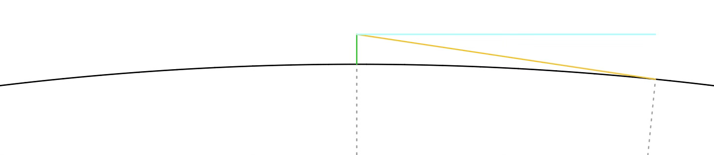
the angle between the light blue and the yellow line is the depression angle, which would be zero if the Earth were flat. Some geometry tells us that this is the same angle between the two radii of the Earth here shown as dotted lines. If the mountain’s height is H then we get
which for small angles yields
In practice the main issue is to measure the direction of the light blue line above: you need a level or a plumb line, and I did not feel like taking one (or worse, making one) on a family trip to the hills.
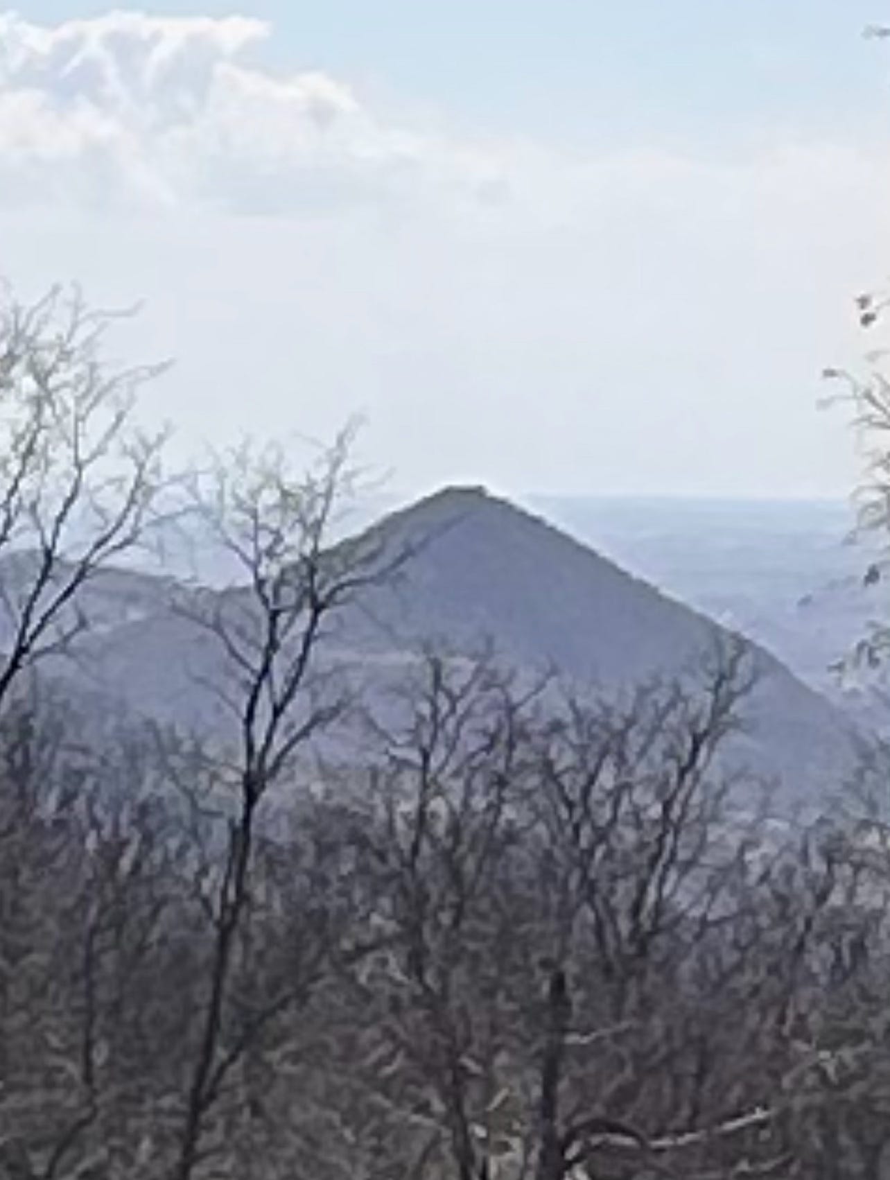
Luckily, last Sunday I had my phone with me, and I could snap a couple of pictures:
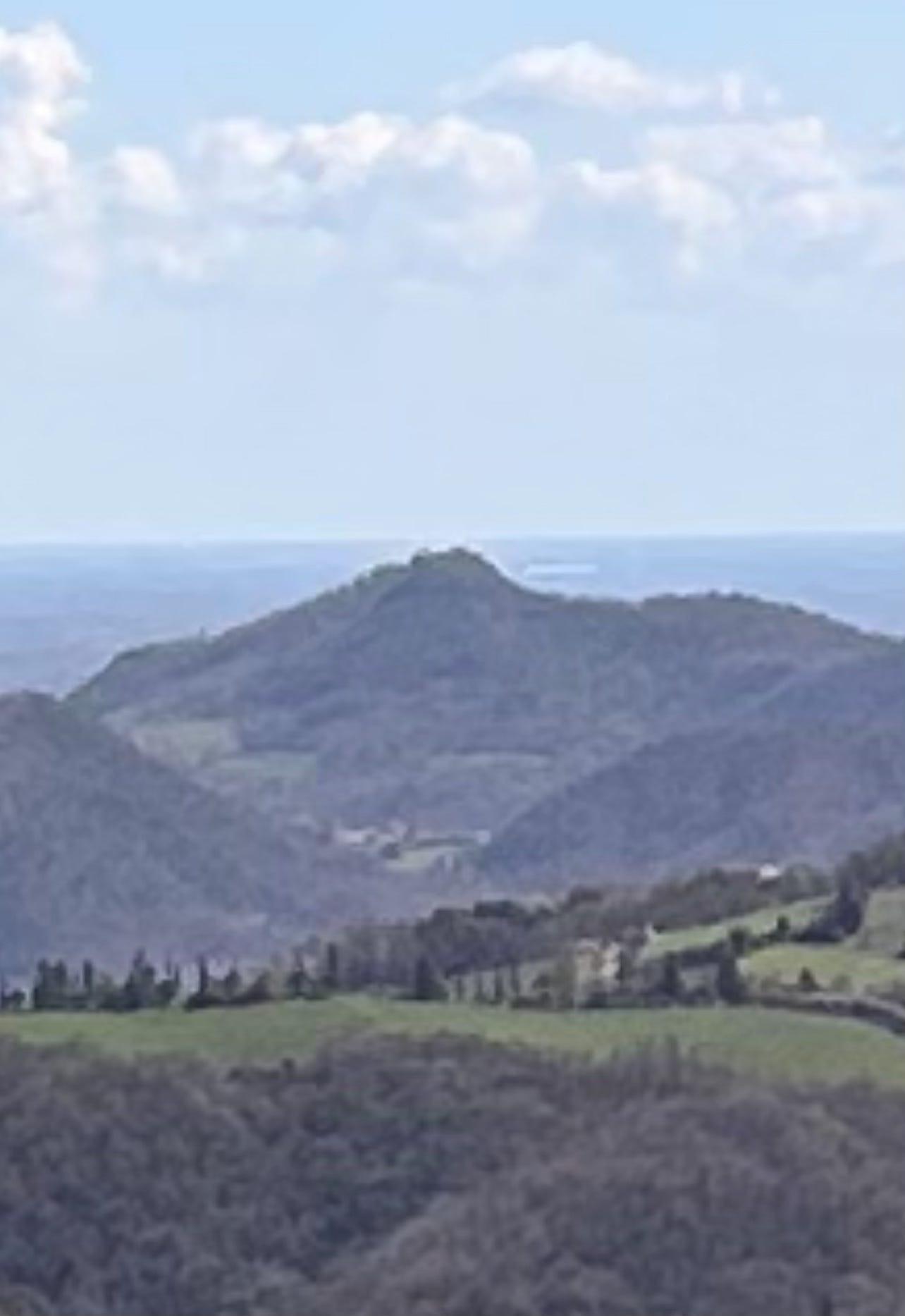
and
These are nearby hills whose tops align pretty well with the horizon as seen from our vantage point. All there is to do then is to calculate
where H is the altitude from which I took the picture, h is the altitude of the top of the nearby hill, and D is its distance. It turns out that to do this you have to know what you are looking at, and this is easier said than done!

The pictures were taken from Passo delle Fiorine, shown with a red cross on the relief map above. The first picture is looking to the South, and my first identification attempt for the peak whose top appears to graze the horizon was the yellow cross, Monte Vendevolo. As it turns out though the altitude of Passo delle Fiorine is 347 meters (plus or minus five, let’s say), as reported on Wikipedia. Vendevolo stands at 460 meters, so the identification was wrong, unless we are looking up to the horizon.
The purple cross is Monte Cinto, 282 meters high. Again let’s give it a 5 meter error bar. The distance is 8770 meters as the crow flies, if we trust Google maps and my ability to click properly on it.
This all works out to
hence the radius of the Earth is (in meters):
off by two standard deviations with respect to the received value of 6378000.
Post-hoc it is quite easy to notice that the top of the hill in the first picture rises slightly above the horizon, so it makes sense that we got a larger radius by underestimating the depression angle.
Moving on to the second picture, that should be Monte Lonzina to the East, 234 meters high and 4750 meters away. This time we get
and the radius is
which is a factor five too small, this time!
This is quite terrible, and taking the average of the two values just feels wrong, even though it would yield something in the neighborhood of seven thousand km, which seems decent.
Again, the second picture shows that the hilltop is somewhat below the horizon, so it makes sense that the resulting calculation underestimates the radius of the Earth. Also atmospheric refraction must play a role… but del senno di poi sono piene le fosse (hindsight is 20/20), so let’s just accept that we live on a -slightly bent- cylinder.